The Odisha government plans to plant mangroves in a coastal areas of Ganjam district at a cost of Rs 33 crore to minimise the impact of cyclones and prevent soil erosion. Mangrove trees slow down the force of a storm by absorbing some of the energy from the cyclones. Thus, they protect the coasts from cyclone damage.
Since Ganjam is identified as vulnerable to floods and cyclones, experts have suggested plantation of mangroves in its coastal belt. Mangrove forests serve as natural barriers during cyclonic events. The district bore the brunt of severe cyclones Phailin in 2013 and Titli in 2018.
The plantation drive will be taken up at Purunabandh, a village located near the mouth of river Rushikulya under the Khallikote range of Berhampur forest division, Odisha Forest department sources said. Around 15,000 mangrove saplings will be planted on six hectares near the village under the United Nations Development Programme (UNDP)-funded Enhancing Climate Resilience of India's Coastal Communities (ECRICC) project.
The project will primarily benefit the fishing community by enhancing climate resilience across 33 panchayats in four coastal blocks of Chikiti, Rangeilunda, Khallikote and Ganjam. For the success of the project, collaboration among various departments like agriculture, horticulture, fisheries, animal resources development, and watershed management is essential, the sources said.
Initially, the mangrove plantation will be conducted on a trial basis in saline zones along the riverside near Purunabandh so that it does not disturb the mass nesting of endangered Olive ridley turtles, which flock near the village in large numbers every year for mass nesting. Already, a mangrove nursery has come up near Purunabandh to facilitate the plantation.
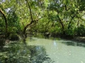
According to the Forest Survey of India-2021 statistics, Odisha's mangrove cover is around 259 square kilometers, spread throughout five coastal districts: Kendrapara, Balasore, Bhadrak, Jagatsinghpur, and Puri. By obstructing the flow of water with their roots/husks and leaves, Mangroves can reduce the vulnerability of adjacent coastal lands from storm surges by slowing the flow of water, but too little use is made of this natural buffer.
Although the potential utility of mangroves in disaster risk reduction is increasingly recognised by coastal managers, efficient use of this ecosystem-based protection is often hindered by scarcity of location-specific information on the protective capacity of mangroves.
The extent of protection from mangroves is determined by the width of the forest, forest density, diameter of tree stems and roots, forest floor structure, bathymetry, spectral features of waves, and the tidal stage at which waves reach the forest.